Map Making

"cARTography is the art to communicate spacial related data graphically"
We make maps.
We produce highly detailed topographic base maps and can process your survey data or management plans. Needless to say we produce all sorts of maps for other uses as well.
Many estates opted to use our topographic base maps. These maps are an extremely feature rich and practical base layer for land management.
Please explore the example categories above.
“Maps play a fundamental role in managing assets.”
Establishing ownership boundary using old maps and documents can be quite a challenge. Due to our extensive experience we have successfully and very efficiently helped many estates recreating their boundaries, mapping them onto current OS maps and preparing the digital files for land registration.
Naturally, we can produced all required management plans, ranging from sales plans, tenancy plans ore.g. forestry management plans.
Please also see our page for GIS & Land management services here.
“Good maps create expectancy of the unseen.”
"expectancy of the unseen": isn’t that just what advertising is all about?
Ironically, the prevailing maps of the 'usual' providers are all too 'familiar' and 'recognisable'. How uninspiring and counter productive.
Our maps can be used as wallpaper in your showrooms, printed on products, in brochures or can be animated for websites.
Example

“Maps tell a story.”
When you are telling a story, either factual or fictionally, we can help drawing your maps; your story.
Yes, graphic designers can make beautiful maps too, but that does not mean that they will convey the right story, particularly if there is a lot of technical or location related data involved.
We are cartographers.
“cARTography is the art of communicating information through a map.”
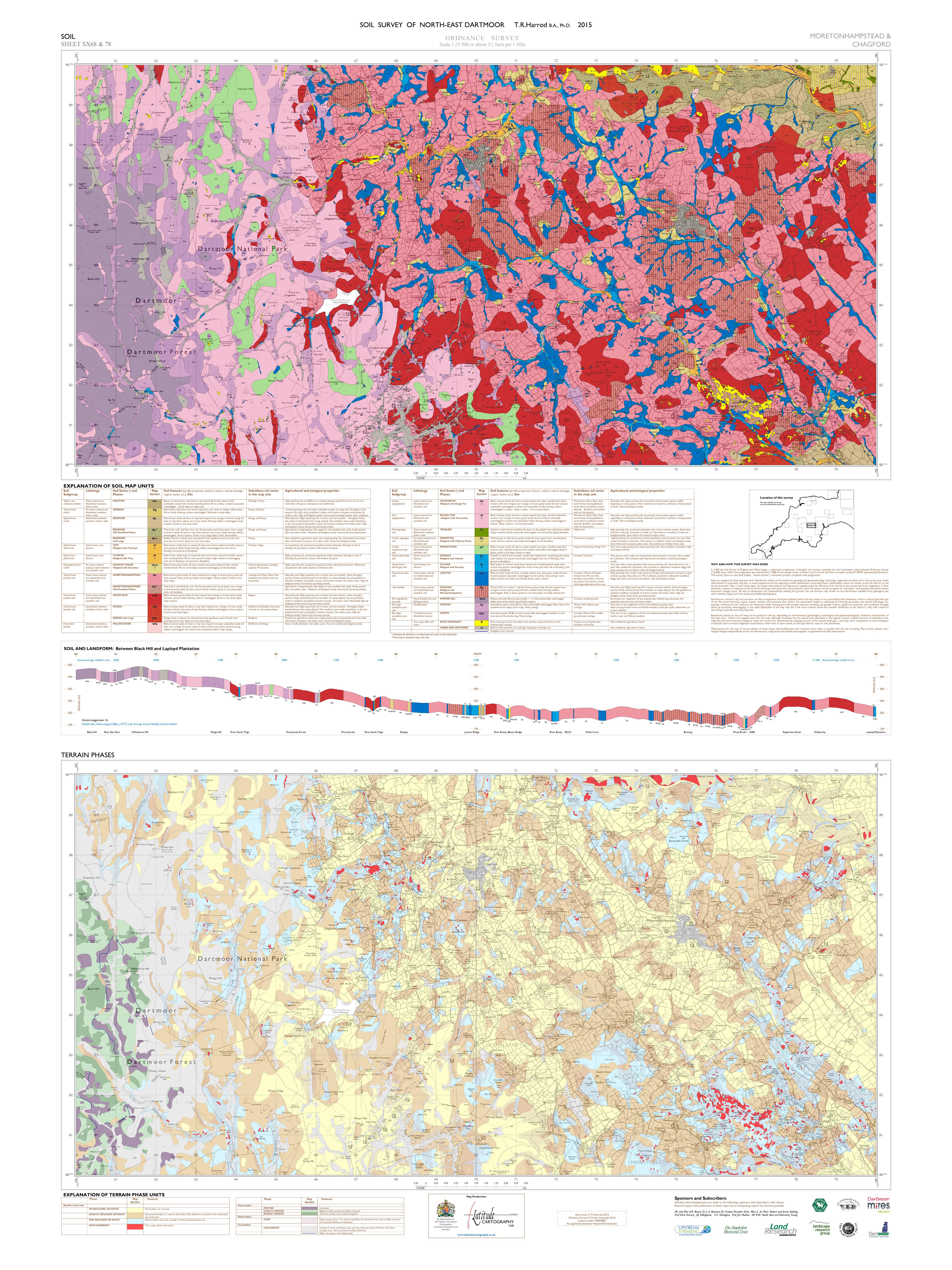
Example: Soils map Dr Tim Harrod


Periodically we get extraordinary requests.
Like the time we were are asked if we could make a map covering a section of the Antarctic; a rather white map! On the other side of the spectrum: we have created a completely pink, stylistic map of southern England in which the commuting time to London governed the distance shown on this map.
In the early days of SatNav we produced a digital map/SatNav system of a part of Cyprus, a working proof of concept.
Example 1 shows three huge maps etched on glass for the Ocean liner Queen Mary 2. Example 2 shows a very detailed map produced for school children on a field trip.
Example 1 Example 2
As practical as digital maps are for management purposes, not everyone enjoys looking at these maps on a screen!
We can produce traditional paper copies of our maps. These can be bound in leather or other materials and can be presented as a single booklet or can be presented as a prestigious boxed set.
Examples


